Ghana’s vulnerability to climate-related hazards, such as floods, is increasing in part due to rapid urbanization and environmental change. Whether for work, education or family related reasons, people in the country often move from one place to another. However, in times of crisis, mobility becomes a challenge, particularly without timely and accurate data on where people are located and their mobility patterns. This makes it difficult for the Governmentto effectively issue public alerts, deliver assistance and make informed decisions to protect lives and livelihoods. Existing systems tend to lack the agility and accuracy to dynamically assess risks, and traditional disaster response methods have been hampered by a lack of up-to-date or near real-time data on population movements. For relevant authorities, such as Ghana’sNational Disaster Management Organisation (NADMO), these limitations often pose a challenge.
The Approach
Data for Good is a global organization and data platform that brings organizations together to leverage data for positive social impact. In Ghana, Data for Good partners include the Ghana Statistical Service, Telecel Ghana and Flowminder. In a project that began in 2017, these organizations worked with NADMO to provide insights on human mobility, with a view to supporting natural disaster planning and response. Data included pseudonymized Call Detail Records (CDRs), a type of metadata used by mobile operators for billing purposes. The Data for Good team leveraged CDRs to provide NADMO with estimates on population displacement after a disaster, as well as dynamic risk maps to assess population exposure and vulnerability to natural hazards. Capacity-building and stakeholder training were also integrated into the project to ensure sustainable, long-term application.
The Benefits
The use of mobile operator data and dynamic risk mapping in Ghana allows NADMO to identify which populations are most at risk and where help would be needed. This leads to more accurate and timely planning, better coordination across agencies and more efficient use of resources during emergencies. This public–private partnership boosts national capabilities, improves how information is used and drives progress on SDG 17: Partnerships for the goals. It also directly supports SDG 11 (Sustainable cities and communities), and SDG 13 (Climate action), helping protect lives and build resilience in the face of climate-related hazards. Additionally, information on population movements post-disaster enables NADMO to identify where people have relocated to, informing response strategies.
40
Percent
of the population is at risk of being affected by a natural disaster.
Ghana faces increasing exposure to natural hazards, with floods posing the most frequent and damaging threat. Each year, around 40 percent of the population is at risk from disasters, many of which are linked to severe flooding events. This risk is intensified by rapid urbanization, which often outpaces infrastructure development and stretches the capacity of city planning and emergency response systems. Poor waste management and weak land use regulations often exacerbate the situation, with blocked drainage systems and unregulated construction in flood-prone areas furthering the impact of heavy rainfall. Climate change adds another layer of complexity, contributing to more erratic and intense rainfall patterns that are difficult to predict and manage.
Understanding how people move before, during, and after a disaster is critical for effective planning and response. Whether for work, education, family or environment-related reasons, people in Ghana often move between rural and urban areas or even within the same location. Without accurate and timely information on where people are located and their mobility patterns, it becomes challenging for the Government to make informed decisions about evacuation planning, resource allocation and long-term risk reduction. The integration of mobility data into disaster management systems unlocks opportunities to address these gaps, enabling more targeted responses that can help protect lives and livelihoods during times of natural disaster.
To address these challenges, the Data for Good partners in Ghana—Ghana’s Statistical Service, Telecel Ghana and Flowminder—who have leveraged mobile operator data since 2017, are now working closely with NADMO to support crisis preparedness, response and recovery.
Using pseudonymized mobile operator data to understand population mobility across Ghana
Understanding population movement is critical to improving disaster preparedness, response and recovery. In Ghana, this has been made possible using pseudonymized call detail records (CDRs) provided by the Data for Good partners.
CDRs are metadata records showing when and where a mobile phone was used, based on the cell tower connection. A record is generated each time a subscriber makes or receives a call, a text, or uses mobile data. Telecel Ghana provides the pseudonymized CDRs, as well as technical support for the operation of the data pipeline. This data is analysed and interpreted by Flowminder and GSS. In support of positive humanitarian and development outcomes, Flowminder provides technical and analytical expertise, in addition to capacity-building to Ghana’s Statistical Service. The data can then be integrated into Ghana’s national data ecosystem.
Once pseudonymized, aggregated and adjusted to remove any biases, these data can reveal general trends in population movement across regions. Crucially, no personal or individual data are shared — only patterns of how large groups move over time. The value of the data not only lies in its timeliness, but also in its robustness and representativeness. Flowminder has developed different methods for short- and long-term mobility analysis, to correct for biases inherent in the data and make it representative of the whole population rather than solely representing the population of Telecel Ghana subscribers. This makes the data more accurate, less sensitive, and more usable for a wide range of use cases and sectors. To understand how Flowminder processes and analyses such data responsibly and confidentially, visit FlowGeek.org a knowledge centre of CDR data analytics for good.
These types of mobility estimates help monitor changes in population distribution over time and identify large population flows such as displacements. In contrast, static data from population data and projections—for example Ghana’s recent 2020 census—only shows a snapshot of the population at the time of data collection, and does not consider short- and long-term mobility.
During a disaster, mobile operator data can help estimate how many people have been displaced, where they have moved to, and provide evidence of when they begin to return. Over longer periods, these data can help detect emerging trends in urbanization or seasonal migration, which can influence future disaster planning.
Incorporating these data into risk mapping enables a more dynamic and responsive view of hazard exposure. Unlike static maps based solely on past census data, mobility-informed maps show a more recent, accurate and frequently updated picture, not just where people were counted years ago. This makes a significant difference in anticipating impact zones and ensuring resources are deployed where they are needed most.
Estimating displacement after natural disasters: Supporting the flood response in 2023
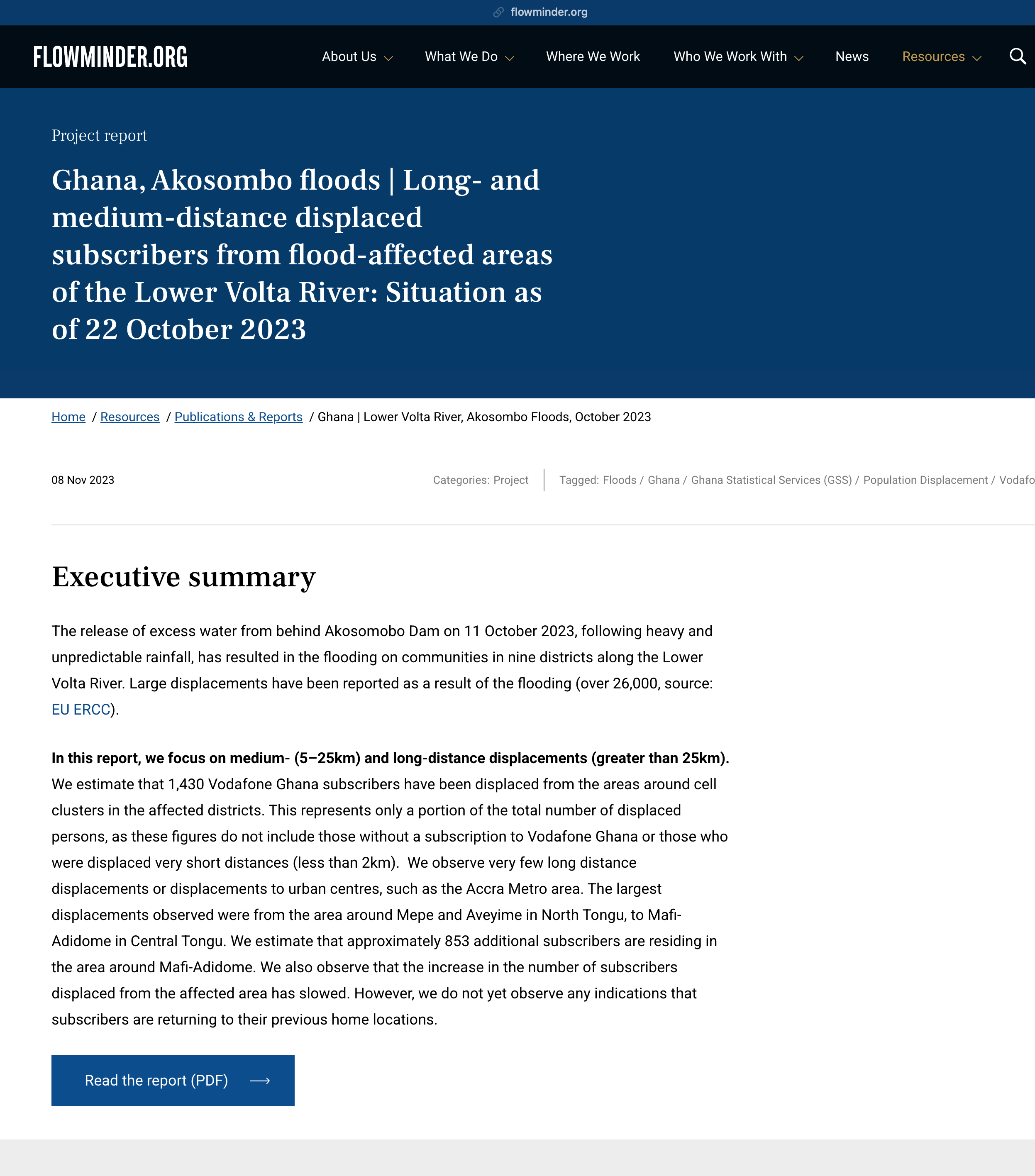
In October 2023, the controlled spillage of the hydroelectric Akosombo Dam located on the Volta River in southeastern Ghana caused widespread flooding, displacing thousands of people across multiple communities. In the aftermath, understanding the scale and direction of population movement was essential for targeted relief efforts. Using mobile operator data, the Data for Good team analysed changes in subscriber locations to estimate displacement patterns resulting from the floods. By comparing data before and after the flooding, and focussing on medium- and long-distance movements, they identified which areas experienced large-scale departures and which areas saw noticeable increases, indicating an influx of displaced individuals. The data showed that large groups of people had moved from the flood-affected areas to nearby towns or across district boundaries. Not only did the data confirm some of the information gathered by NADMO on the ground, it also revealed unexpected locations that informed local responders’ efforts.
Commenting on the use of data for events such as the Akosombo Dam spillage, Kelly Kekely Degboe, Head of the Emergency Operations Centre (EOC) & Information Technology (IT) at NADMO said, “The dynamic risk maps, unlike the static maps, gave us realistic information about the situation on the ground and what we could expect; this helped us to be better prepared before we moved into action.” He continued, “By freezing the mobility data from GSS and Flowminder, we can get an estimated number of people on the ground at a particular time during the day, the week, or even the season of the year, to help us in our preparedness and response planning.”
This use of mobility information enabled more informed decisions, demonstrating how mobile operator data can complement traditional response mechanisms in times of crisis.
Interested in learning more? Read Flowminder’s full report on the Akosombo flood displacement.
Mapping hazard risk dynamically
In addition to supporting disaster response, mobility information derived from CDR data provides critical insights for crisis preparedness. This improves NADMO’s predictive capability regarding populations at risk of being affected by natural hazards.
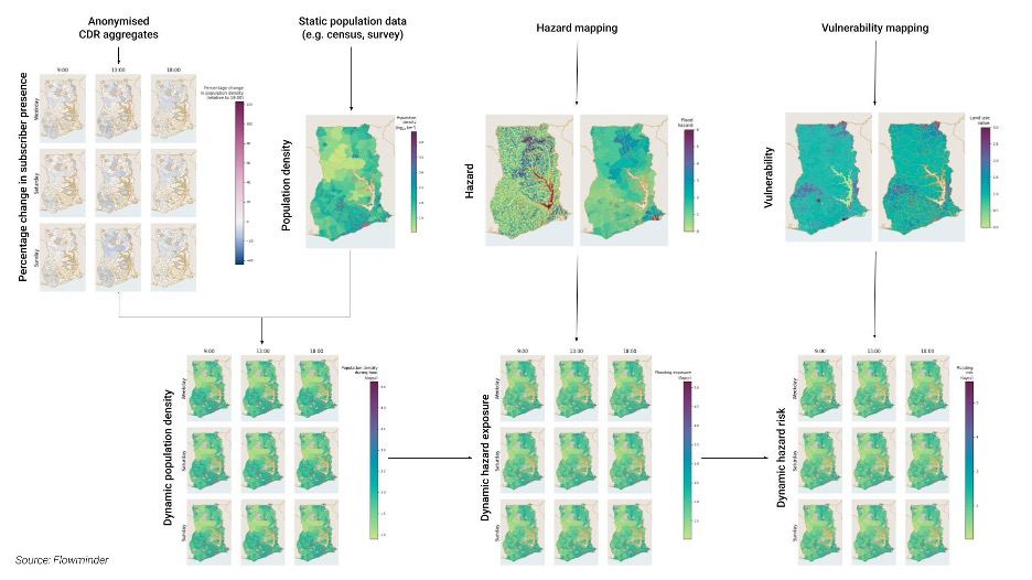
Traditional disaster risk maps rely on static census figures and generalized assumptions about hazard exposure, which limits their effectiveness in changing environments. In response, the Data for Good project provided NADMO with a dynamic approach to risk mapping, combining pseudonymized CDR data with static population data, geospatial hazard and vulnerability data. These maps provide estimates of the number of people in an area over time, both in the short term (hourly, daily) and in the long term (monthly, seasonal), and therefore how many people may be exposed to a hazard at a given time.
Figure: Data pipeline combining CDR-derived mobility data with flooding hazard and vulnerability geospatial data to calculate dynamic, district-level flooding risk.
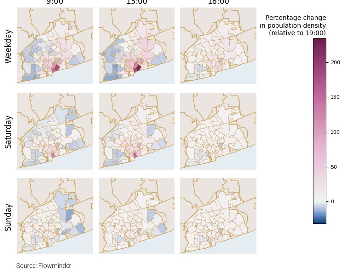
Figure: Data visualization of dynamic flooding risks, with percentage changes in population density, based on anonymized CDR aggregates.
The maps help authorities assess population exposure to hazards and anticipate areas of greatest need. This method provides an up-to-date, evidence-based understanding of how many people are at risk, where, and when. These dynamic maps allow for more accurate scenario planning and improved coordination among government agencies and disaster responders.
How can better data contribute to better policy?
Local capacity-building is central to this work:
Ghana’s Statistical Service, as the national depositary of data, plays a key role in integrating the data into the national data ecosystem and championing its use by other national actors;
Flowminder is supporting as technical service and capacity-strengthening provider; and
Ghanaian institutions have been trained in how to interpret the data, which is important for institutional capability-building and informing long-term planning.
Through the Data for Good partnership, NADMO and other ministries and agencies now have access to timely data on population mobility, enabling them to make more informed decisions by taking into account changes in population numbers over time.
To continue responsibly leveraging CDR data for disaster management, assessing their limitations (e.g. duplicate records, multiple SIM ownership) and embedding safeguarding protocols at every step of the data analysis remain crucial.
Where do we go from here?
Ghana’s Statistical Service, Telecel Ghana and Flowminder continue to work with NADMO to strengthen data use. This includes reviewing NADMO’s hazard portfolio to identify further applications besides flooding; implementing protocols to strengthen responsible data sharing between the organizations; and integrating features of interest to NADMO (e.g., healthcare facilities) into reporting systems.
Listen in! Hear Ghana’s Statistical Service discuss the benefits of mobile operator data (7-minute video)
Listen to representatives from NADMO discuss the benefits of mobile operator data for improved decision-making, and how they are using mobility insights provided by the Data for Good partners.

%20(1).jpg)